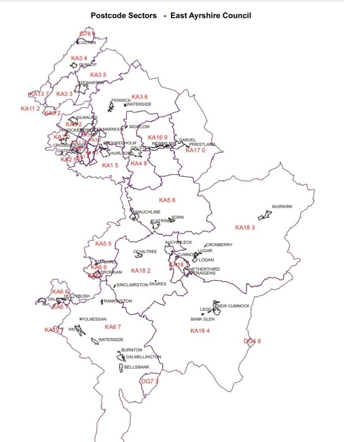
East Ayrshire Overview
East Ayrshire, council area southwestern Scotland. It covers an undulating swamp in the north and west that ascents to forested and moor-canvassed uplands in the east and south, where the Blackcraig Slope arrives at a height of 2,298 feet (700 meters). East Ayrshire shapes part of the noteworthy province of Ayrshire. Dairy cultivation is significant in the swamps, while cows and sheep bringing prevail up in the uplands. Kilmarnock is the gathering region’s regulatory focus and the biggest town
East Ayrshire City of Scotland | |
Sovereign state | United Kingdom |
Country | Scotland |
ONS Code | S12000008 |
Area | 1,262 km2 |
Population | 121,840 |
Postcode Areas | DD1-5 |
Area code | KA1.2.... |
All regions in East Ayrshire | Postal Code |
Annandale | KA1 |
Auchinleck | KA18 |
Caprington | KA1 |
Catrine | KA5 |
Coalhall | KA6 |
Cronberry | KA18 |
Crookedholm | KA3 |
Crosshouse | KA2 |
Cumnock | KA18 |
Dalmellington | KA6 |
Dalrymple | KA6 |
DarvelK | A17 |
Drongan | KA6 |
Dunlop | KA3 |
Fenwick | KA3 |
Galston | KA4 |
Gatehead | KA2 |
Glenbuck | KA18 |
Glencairn Industrial Estate | KA1 |
Hollybush | KA6 |
Hurlford | KA1 |
Kilmarnock | KA1, KA2, KA3 |
Kilmaurs | KA3 |
Knockentiber | KA2 |
LoganK | A18 |
Loreny Industrial Estate | KA1 |
Lugar | KA18 |
Lugton | KA3 |
Mauchline | KA5 |
Moscow | KA4 |
Muirkirk | KA18 |
New Cumnock | KA18 |
Newmilns | KA16 |
Ochiltree | KA18 |
Patna | KA6 |
Priestland | KA17 |
Rankinston | KA6 |
Skares | KA18 |
Sorn | KA5 |
Stair | KA5 |
Stewarton | KA3 |
Trabboch | KA5 |
Waterside | KA3 |